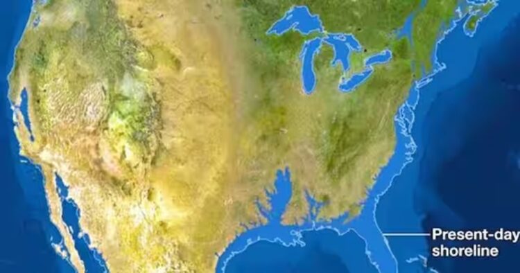
Earlier this March Astrophysicist Neil DeGrasse Tyson posted a picture of a U.S. map that shows Florida and America’s East and Gulf Coasts underwater on X, formerly known as Twitter.
The post captioned, ‘In Florida, at 345 feet, Britton Hill is the highest elevation — the lowest highest elevation in the United States. This makes Florida supremely susceptible to sea-level rise during Climate Change. An objective truth even if you don’t believe in Climate Change. Just Sayin’’.
The map is from National Geographic’s September 2013 issue, which depicted what the map of different continents would look like if the sea level rose by 216 feet once all of the world’s ice melted.
However, scientists believe that this scenario is not approaching and it would take over 5000 years for it to become real.
However, a faction believes that if we continue emitting greenhouse gases and increasing our carbon footprints it will become Earth’s reality far sooner.
Florida is not the only area being affected by it, parts of South America would drown in the sea, and Denmark and the Netherlands would be a small set of islands.
David Thornalley, a professor of ocean and climate science at University College London, stated that while this scenario is quite extraordinary, it is possible.
‘In the long term, even under more moderate emission scenarios, sea level rise after a few hundred years is expected to be in excess of 10 meters [33 feet]. So the picture Neil shows is not that far-fetched, it is simply that this scale of sea-level rise will take centuries to millennia to occur, assuming we don’t lower GHG levels’, he said.
According to the Intergovernmental Panel on Climate Change (IPCC), by 2100 the sea level will rise a few centimeters but the possibility of it raising 2 meters is still there.
Projections by the National Oceanic and Atmospheric Administration say that even a 3-foot rise in sea level will Florida’s coastline and New Orleans drowned in the sea.


Comments